By Robert R. Stieglitz
Rutgers University, Newark
2000
Tel Tanninim 'Crocodiles Mound', (Tell al-Milāt 'Mortar Mound') is situated on the Mediterranean coast of Israel, some 5 km. north of Caesarea Maritima, at the outflow of Nahal Tanninim 'Crocodiles River'. Indeed, there were Nilotic crocodiles in the river, as well as the adjacent Kabbara marsh, now drained. The last of the reptiles was killed shortly after 1905. The tel has been identified with Hellenistic Krokodeilon polis 'Crocodiles City, (Strabo 16.2.27 and Pliny NH 5.17.75 ). In Byzantine times, the settlement marked the northern municipal border of Caesarea and can be identified with the place named Migdal Malhā in the Jerusalem Talmud (Demai 2:1,22c). The Latin name Turris Salinarum, a translation of the Aramaic name, was still in use during the Crusader period. Both names mean 'Saltworks Tower', referring to the production of sea salt, from coastal pans, or to a salted-fish industry at the site.
 Surface surveys had indicated the site was occupied from the Persian to the Crusader period. A brief salvage excavation in 1979 unearthed substantial Byzantine remains along the eroded western edge of the tel. Systematic excavations directed by the present writer took place from 1996-99. The earliest pottery, excavated at the lowest stratum of the tel, indicates that the settlement was a Phoenician foundation in the fifth century BCE, no doubt after this stretch of Palestinian coast was ceded by the Persian emperor to his vassal the king of Sidon. The Phoenician name of the site remains unknown. The latest finds were Ottoman, presumably connected with the construction of the now-ruined Kaiserbruecke across the Crocodiles River at the foot of the tel.
The finds in Area A include remains of several structures from the Crusader, Islamic and Late Byzantine periods, which were built atop the foundation walls of a large Early Byzantine church, whose floors were covered with multi-colored mosaics, poorly preserved. Below the Early Byzantine level was a gap, marked by a thick layer of sterile sand, and below that a thick layer with structural and ceramic and other remains of the Persian-Hellenistic settlement.
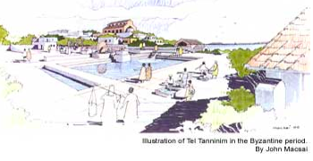
In Areas B and B2 were found fishponds (Latin: piscina) for breeding of freshwater fish and in Area D and the western coastline were several ponds for saltwater fish. The freshwater ponds were supplied with running water by the Tel Tanninim Aqueduct, which tapped into the high-level aqueduct of Caesarea, had thick plastered walls and utilized a system of embedded ceramic jars either within the walls or along the floor to create a series of cells (Latin: speci) for the freshwater fish, such as the tilapia (St. Peter's fish) bred and grown in the ponds. Each breeding pond had a small tank with a mosaic floor built nearby, presumably for holding and sorting fish. The aqueduct and breeding ponds were evidently built in the fourth century CE and continued to operate through the end of the Seventh century.
Sometimes in the Sixth century CE, the water flow in the aqueduct of Tel Tanninim was disrupted, but the freshwater fishing industry at the site continued to operate with well water. The water was drawn from a round well-built stone well, three meters in diameter, dug into the aquifer adjacent to the breeding pond in Area B2. Across the well's center a wooden wheel had been installed, around whose perimeter were attached a series of ceramic jars, fragments of which were found. In Talmudic sources, this type of pump is called an 'antelayyā-wheel.
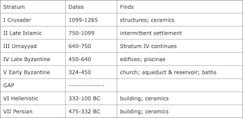
The stratigraphic table below summarizes the occupation history of Tel Tanninim: