By Oded Borowski
Middle Eastern and South Asian Studies
Emory University
May 2010
The Site
Tell Halif (in Arabic Tell el-Khuweilifeh) is a prominent mound situated in the southern Shephelah (low hill-country) on the southwestern flank of the Judean Hills approximately 15 km (10 miles) northeast of Beer-sheba (Israel).
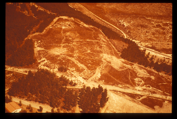
Fig. 1. Tell Halif: Aerial view from the south.
The tell overlooks the coastal plain and guards the approach to the hill-country from the Via Maris (Way of the Sea).
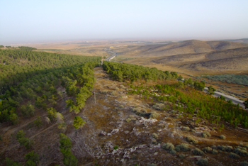
Fig. 2. Tell Halif: Looking west to the Coastal Plain.
In biblical times, the site was probably known as Rimmon or En Rimmon, which means Pomegranate or Spring of the Pomegranate, respectively.i Rimmon, being also an epithet of the Canaanite deity Hadad, might reflect some connections to the pre-Israelite population. The names Rimmon and En Rimmon appear in the Bible (Josh 15:32; 19:7) in a regional context suggesting their identification with Tell Halif.ii According to biblical traditions, the region was first allocated to the tribe of Simeon and later to Judah.
History of Excavations
Excavations at the mound have been conducted in four phases starting in 1976 by the Lahav Research Project (LRP).iii The objectives of Phase I, under the direction of Joe D. Seger (Cobb Institute of Archaeology/Mississippi State University), were to establish the stratigraphy (order of occupational layers) of the site; these were carried out in four seasons (1976-77, 1979-80). Phase II (1983, 1986-87, 1989),iv also under the direction of Joe D. Seger, was devoted mostly to the study of the remains from the Early and Late Bronze Ages. Phase III (1992-93, 1999), under the co-direction of Paul F. Jacobs (Cobb Institute of Archaeology/Mississippi State University) and Oded Borowski (Emory University), concentrated on the remains from the Iron Age II (8th century BCE). Phase IV (2007-09), under the direction of Oded Borowski, continues to explore the remains from the 8th century BCE town to further understand the nature of daily life in that period.
Excavations were carried out in Field I located on the eastern slope; Field II - on the summit; Field III – on the northwestern end of the tell; Field IV – on the southwestern edge of the tell; Field V – south of and adjacent to Field IV; and at various locations off the mound such as the Eastern Terrace and the Iron Age II cemetery southwest of the tell.
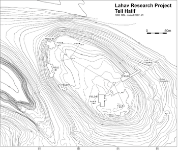
Fig. 3. Map of excavated areas on the tell.
A regional survey was conducted to supplement the occupational and economic history of the site. Excavation results yielded remains of nineteen strata some of which are divided into sub-strata and local phases of settlement. In general, the site was first settled in the Chalcolithic period (3500-3200 BCE) and has been occupied with some gaps to this day.
History of the Site
The earliest settlements, Strata XIX-XVI (3500-2900 BCE), occupied the Eastern Terrace close to the cultivable lands, first in improved natural caves and later in domestic structures that formed a small village. After a gap of about 300 years, the site was reoccupied during the Early Bronze IIIA1 (2600-2500 BCE) further up the hill (Stratum XV); however, this time it was massively fortified as can be seen by the remains of a 7.5 m-wide tower, a 3.5 m-wide defensive wall, and a glacis (a sloping rampart). The settlement came to its end in a fiery destruction that produced a layer of ash and other debris 3.5 m deep. The site was reoccupied again in the Early Bronze III (Strata XIV-XII; 2500-2300 BCE), but was not re-fortified.
Settlement was resumed at the tell during the Late Bronze Age IA (Stratum XI; 1550-1475 BCE) following a gap of about 750 years (EB IV-MB II). After a transitional period that yielded several sub-phases that produced typical ceramics and a Hyksos-type scarab, the site where Field I is located was occupied by a large building with a central courtyard (6x6.5 m) surrounded by rooms on all sides (Stratum X; 1475-1400 BCE) (Jacobs 1987). This type of structure, known as a “residency” building, is associated with Egyptian rule in Palestine. This stratum came to its end with a massive destruction and was followed by a partial resettlement as Stratum IX (1400-1300 BCE). Some time afterwards in the later part of the Late Bronze Age (LB IIB, Stratum VIII; 1300-1200 BCE) a large mud brick platform was constructed on top of the remains of the previous strata (X-IX). A series of stone-lined storage pits was built into the platform, and it seems that the site was used as a storage center for grain, probably serving as an entrepôt.
Remains from the Iron Age I (Stratum VII; 1200-900 BCE) were uncovered in Fields I-III. Because of the limited exposure, very little can be said about the nature of the settlement at that period. Architectural finds in Fields II and III include stone-lined storage pits, probably for grain. Remains from Fields I and II include degenerate-style Philistine pottery, which suggests connections with the coastal plain. From Field II came a headless clay female figurine the front of which was decorated with punctates and the back with long, etched vertical lines resembling hair (Dessel 1988).
The greatest exposure of any strata is that of the Iron Age II Stratum VIB (800-700 BCE) and Stratum VIA (700-650 BCE), both of which are close to the tell’s surface and could be exposed easily. These strata yielded much information about daily life in their respective periods, a topic to be discussed in detail below.
The latest strata on the tell date from the Persian (Stratum V; 500-300 BCE) and Hellenistic (Stratum IV; 300-100 BCE) periods. Pits dated to the Persian period were found in Fields I, III and IV while in Field II the remains of a large building, possibly administrative, were uncovered. Ceramic evidence suggests that the building was constructed in the late Persian period. In Field IV, over 560 fragments of clay figurines were found scattered mixed with topsoil (<http://www.cobb.msstate.edu/dig/>). It seems that these fragments originated at a cult site on the tell and were brought to the area of Field IV during ground leveling activities, probably for agricultural purposes. Recently, several figurine fragments were found during excavations in Field V.
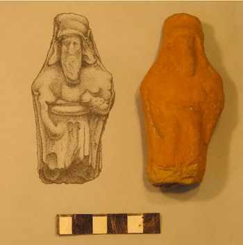
Fig. 4. Persian period figurine.
On the summit of the mound in Field II, architectural remains belonging to Stratum IV were found including remnants of a residential building as can be determined by the several ovens found on the living surfaces.
During the Roman/Byzantine periods (Stratum III; 200-600 CE) the tell itself was sparsely occupied and its surface might have been used for agricultural and grazing activities. Remains of a structure from this period were recently uncovered in Field V. The main settlement took place on the Eastern Terrace and at other sites in the vicinity such as Horvat Rimmon (Khirbet Umm er-Rammamin), about 1 km south of Tell Halif. The Jewish nature of the population in the region at the time is attested in Eusebius’s Onomasticon, where the early church father describes the existence of two Jewish villages in the area, Tilla and Rimmon. Cemeteries belonging to these two villages were excavated by several archaeologists at various times.
The Terrace was resettled in the Early Arab period (ca. 700 CE), and the area surrounding the tell saw some action during the Crusades. Modern Arab settlement, mostly in caves, occupied the foot of the tell at Khirbet Khuweilifeh until 1948.
As previously mentioned, the greatest exposure made was of Strata VIB and VIA. Both are related to each other; both strata belong to the Judahite town that occupied the mound during the Iron Age II. Both strata produced a tremendous amount of information that enables us to reconstruct what life was like in a small town in the Judean kingdom in the Shephelah. The reason that this study can be undertaken is the fact that at the end of the eighth century BCE, the site suffered total destruction by fire that was caused by a military assault, which can be detected in the archaeological record.
Stratum VIB, parts of which were preceded by Stratum VIC that is dated to the 9th century BCE, contains remains of destroyed structures covered with a thick layer of ash produced by a fire hot enough to calcify the mud bricks. This fire also helped preserve organic matters that became charred or carbonized. That the fire was a result of a military action is evident by the numerous arrowheads, sling stones, and remains of other weapons uncovered in the destruction context. Since the end came fast, most of the contents of the structures remained in situ (in place) and we get a freeze-frame picture of life at the point just before the destruction took place. Had the inhabitants had the time to leave the place leisurely, they would have removed much of the contents. Furthermore, Stratum VIA, which was inhabited possibly by refugees from Stratum VIB, was abandoned in haste with the contents of the structures also left intact behind. The way these two strata reached their end enables us to reconstruct life as it was just before the demise of the town. Now we know that a major occupation of the local inhabitants was textile production, as seen from the large number of clay loom weights and other tools.
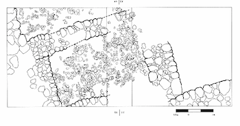
Fig. 5. Tell Halif: Stratum VIB, Plan of textile workshop.
The date of these two strata, end of the eighth-beginning of the seventh century BCE, is easily secured by the type of pottery left behind, which is typical of that period. The similarities between the two assemblages suggest very strongly that the occupants of the two strata were related. The written sources, both biblical and extra-biblical, suggest that the end of the two strata was the result of Assyrian military activities in the region. It is most likely that King Sennacherib in 701 BCE destroyed Stratum VIB during his march from Philistia to Lachish and Jerusalem when he tried to quell the revolt led by King Hezekiah of Judah. There is much evidence for this chain of events. As Sennacherib claims in his own words inscribed on his prism, “I laid siege to 46 of his [Hezekiah’s] strong cities, walled forts and to the countless small villages in their vicinity, and conquered (them) by means of well-stamped (earth-) ramps, and battering-rams brought (thus) near (to the walls) (combined with) the attack by foot soldiers, (using) mines, breeches as well as sapper work.”v In another inscription we read: “I laid waste the large district of Judah (Ia-ú-di) and made the overbearing and proud Hezekiah (Ha-za-qi-a-a-a), its king, bow in submission.”vi The Bible makes several references to the revolt. 2 Chronicles 32:1 says “…that King Sennacherib of Assyria invaded Judah and encamped against the fortified towns….” In 2 Kings 18:13 some of the devastating results of the conflict are described: “In the fourteenth year of King Hezekiah’s reign, King Sennacherib of Assyria attacked and captured all the fortified towns of Judah.” Tell Halif must have been one of these towns. Continuous Assyrian hostile activities must have been the cause for the abandonment of Stratum VIA.
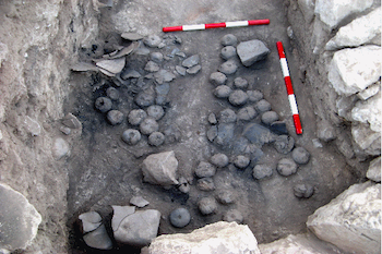
Fig. 6. Tel Halif: Stratum VIB, Loom weights in Situ.
Notes:
i For a discussion of the biblical identification of the tell, see Borowski, O. (1988). "The Biblical Identity of Tel Halif." Biblical Archaeologist 51: 21-27.
ii Other proposed identifications have been Sharuhen, Ziklag, Hormah, and Goshen.
iii LRP is a consortium of American institutions led by a group of American scholars.
iv A short salvage excavation season was conducted in 1985 under the direction of P.F. Jacobs. A salvage effort at the Iron Age II cemetery on behalf of the IAA (then the Dept. of Antiquities and Museums) was carried out in 1988 by the present author, see Borowski, O. (1992). The Iron Age Cemetery at Tell Halif. Eretz Israel: Biran Volume. Jerusalem, Israel Exploration Society. 23: 13*-20*, Borowski, O. (1992). "The Iron Age Cemetery at Tell Halif." Qadmoniot(95-96): 89-92. (Hebrew), Borowski, O. (1993). Halif, Tel; The Iron Age Cemetery. The New Encyclopedia of Archaeological Excavations in the Holy Land. E. Stern. Jerusalem, Israel Exploration Society. 2: 559-560, Borowski, O. (1994). "Finds from the Iron Age Cemetery at Tel Halif, 1988." 'Atiqot 25: 45-62.
v See Pritchard, J. B. (1969). Ancient Near Eastern Texts Related to the Old Testament. Princeton, NJ, Princeton University Press.
vi Pritchard 1969: 288.