Davidic and Solomonic Bazaars, Barracks, Stables, Warehouses, Toll Stations,
Tripartite Pillared Buildings, or Entrepôts...
Beyond the Structures Themselves
By Jeffrey Blakely
Visiting Professor, Department of Hebrew and Semitic Studies
University of Wisconsin--Madison.
May 2003
INTRODUCTION
The first tripartite pillared buildings (henceforth TPBs) were excavated by F. J. Bliss in the course of his pioneering stratigraphic excavation at Tell el-Hesi in November 1891. Bliss did not know what they were, calling them a “fascinating structure of parallel walls and stones,” and speculating that it might have been a “bazaar with streets between the lines of chambers” (1892: 100; 1894: 95). An unnamed person suggested to him that “The buildings contained barracks for soldiers” (1892: 100; 1894: 96; Matthers 1989: 53). Bliss dated this “fascinating structure” to his City V, what we would call, in general terms, the Iron Age. The structure did not attract much attention for some years thereafter.
Clearly the most famous examples of TPBs are those excavated at Megiddo (Guy 1931: 37-48; Lamon and Shipton 1939: 32-47); some of which were soon dubbed “Solomon’s stables.” These later examples initiated a debate over the exact dating of these structures (i.e., can they be Solomonic?) and their function (i.e., are they really stables?). If one looks at this lively discussion, it soon becomes apparent that the debate centered on the physical character of the structures themselves (e.g., in English, Pritchard 1970; Yadin 1976; Herzog 1973, 1992: 223-28; Holladay 1986; Herr 1988; Currid 1992; Kochavi 19898a, 1998b, 1999). Rarely did questions concerning the locations and character of the sites that contained these structures get examined (see, however, Holladay 1997a).
In almost any study of TPBs, they are viewed as governmental (or barely possibly private economic) structures in some sense: bazaars, barracks, stables, warehouses, or entrepôts. To find such structures at ports, along international trade routes, in capital cities, and in regional military and economic centers, then, would not be surprising. To such a list, therefore, finding such structures at Tell el-Hesi seems anomalous. This is certainly a minor site. If one can suggest a reason for their presence at Tell el-Hesi, might their function at other sites be clarified?
BLISS’S CITY V AT TELL EL-HESI
Tell el-Hesi (10631245) is located in an area roughly where the coastal plain, the Shephelah, and the Negev run together, about 26 km ENE of Gaza, 53 km W of Hebron, about 11 km WSW of ancient Lachish, and about 8 km SW of modern Qiryat Gat. Bliss’s excavation of his Cities IV, V, and VI in 1891 and 1892 has been augmented through the work of the Joint Expedition to Tell el-Hesi, which excavated at the site from 1970 through 1983. It is now clear that the redefined Stratum X is Bliss’s City IV and that this Late Bronze Age level was destroyed and abandoned, 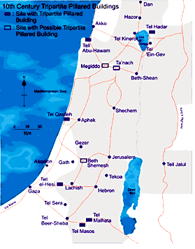 probably in the middle of the 12th century B.C.E. (Blakely 2000). The redefined Stratum IX is City V. The site’s massive fortress, now called Stratum VIII, is City VI. This structure probably dates to the early 9th century B.C.E. and must be viewed as a satellite site of Judahite Lachish (Blakely and Horton 2001). Bliss’s City V, or Stratum IX, is sandwiched in between, sitting directly below part of the fortification system of Stratum VIII/City VI.
Bliss’s City V must date, therefore, somewhere to the period from mid-12th to early 9th centuries B.C.E. Unfortunately, in the part of the site excavated by the Joint Expedition, this stratum had been totally removed by the builders of Stratum VIII. Fortunately, great quantities of 10th-century pottery, forms earlier in date than those found on the floors of Stratum VIII, are found in residual contexts about the site. On the other hand, only a scant few 11th -century forms or Philistine pottery of any date are found at the site. Thus, it would seem that Bliss’s City V must date, in large part, to the 10th century B.C.E. (Blakely and Horton 2001).
Based largely on the continuous nature of the material culture remains at the site and the identification of Stratum VIII/City VI as Judahite, Blakely and Horton (2001) suggested that the site was Judahite throughout the 10th through mid-8th centuries B.C.E. In 1971, Wright suggested that Hesi and some of its neighboring sites were border forts and fortresses of Judah. The analysis of Blakely and Horton tends to support this view when one recognizes that no fortifications similar to Hesi VIII and no sites with 10th through 8th centuries Judahite (as opposed to Philistine) pottery are known immediately to the north, west, or south of Hesi.
If, as Blakely and Horton believe, the site is Judahite in the 10th through 8th centuries, why was the site of Hesi built where it is? That answer is probably two-fold. First, the site has a natural source of fresh water, Ayun Hesi, which pools at the base of the site in an otherwise barren loessal plain. Secondly, and probably equally important, Hesi seems to have been located on the main road leading from Gaza to Hebron. This road has received little attention, but it was certainly active from the Roman/Byzantine Period through the 19th century (e.g., Lecker 1989; Hartmann 1916: 488; Fabri 1893: 422-28; Poujoulat 1841: 243-44), and since it served the vital function of connecting Gaza and Hebron, one must assume that it was significant in all other periods in which these two cities were prominent, unless there was a compelling reason for the road not to be there. Thus, fresh water and a position on a major road probably explain the location of Hesi, and its material culture suggests that the site was Judahite. What about Bliss’s City V, specifically? For the reasons just enumerated, Hesi served some Judahite border function in the 10th century B.C.E.
KOCHAVI’S MAP AND SERIATING 10th-CENTURY TPBs
In 1998 and 1999, Moshe Kochavi published a series of articles that dealt with TPBs and their distribution. Kochavi divided TPBs into three basic groups, early (11th and 10th centuries), late (9th century and later), and TPBs of unknown date (1998a: 471 and fig. 8; 1998b: fig. 2), and then he mapped them. Kochavi included Hesi’s TPBs in the unknown date group, but, as just suggested, Blakely and Horton argued that Bliss’s City V was 10th century and that it was located on the Gaza-Hebron road, not an inner coastal road as Kochavi suggested. When Blakely and Horton added Hesi to the proper road and examined Kochavi’s map, they saw that the earlier 11th and 10th centuries TPBs formed the perimeter of a polygon, and they then suggested that these buildings must have been operated by the political group located “within this circle of sites and not by the various polities outside the circle” (Blakely and Horton 2001: 9). If this were true, then the sites must have served some military, political, or economic function on a “political” border.
Kochavi dated his 10th-century TPBs largely on the basis of the original excavators’ assertions (1998a, 1998b). Then Blakely and Horton (2001) and later Blakely (2002) suggested that Kochavi’s 10th-century TPBs, along with the addition of Hesi, were located along trade routes at the borders of the United Kingdom/Monarchy of David and Solomon with their neighbors. The following paragraphs will examine the precision of some of these 10th-century dates and will suggest that a few more TPBs might also be 10th century.
Tel Hadar, Kochavi’s own site, illustrates a significant question relating to its date of destruction. Kochavi suggested about 1000 B.C.E in 1998 (both a and b) and 1999, but more recently a date as late as 980 B.C.E. has been suggested in the final report of this work (Beck and Yadin, forthcoming). Even that is questionable. A date in the 10th century seemingly is warranted, but is it early, late, or in the middle of that century? A Proto-Geometric bowl krater found in the destruction of Hadar’s TPB is dated from about 900 B.C.E in the traditional Greek chronology, a date a century off from how Kochavi, Beck, and Yadin date the local pottery (Kopcke 2002). To muddy the waters further, how much before the destruction did this bowl krater arrive at the site: a day, or a year, or a few decades? Was the bowl krater new when it arrived at the site? Does either the Greek or the Palestinian chronology have to be altered, and by how much? What are the implications (Kopcke 2002, forthcoming; Fantalkin, 2001)? Did the destruction occur under Geshurite control or Israelite? There are many questions here. For now, a general 10th-century date remains reasonable.
Recently, Bunimovitz and Lederman (1997: 48, 75) have suggested that the TPB at Beth-Shemesh dates to the mid-10th century, not the indefinite 10th-7th centuries Kochavi accepted (1998a: 471, fig. 8; 1998b: fig. 2). Finkelstein has dismissed this dating of the site (2002: 121-22), but until a more thorough publication of the finds and stratigraphy appears, no definitive chronological statements should be made. The suggestion of Bunimovitz and Lederman is certainly tantalizing. Given the stratigraphic context of this TPB as described by Bunimovitz and Lederman and more or less agreed to by Finkelstein, it would seem that it should date no later than the 9th century.
What about the probable TPB at Tell Ta’anach (Sellin 1904: 18, 104; Guy, 1931: 44 and fig. 32; Currid 1992: 56, 61 n.11)? This site was not even mentioned by Kochavi, but the fragmentary evidence published by Sellin and described by Guy suggests that at least one TPB was present at Ta’anach. Rast’s study of the Iron Age ceramics describes Periods III through V as fragmentary, having been pitted out in the Persian and Arab period (1978: 41-45). This suggests that a structure excavated by Sellin and still extant when Guy visited the site must predate Period III. Period II (late 11th and 10th century) would seem to be preferred to Period I (12th century) (dates based on Rast 1978: 3-6) given that no 12th-century examples of such a structure are known. It is speculative, but if this is in fact a TPB, then a 10th-century date seems most likely.
Kochavi (1998a, 1998b) accepted an 11th-century date for the TPB Tel Masos based on the final reports of Fritz and Kempinski (1983). This makes Masos one of the earliest sites to have a TPB. Based on his study of red slipped and red-slipped burnished pottery (Holladay 1990), Holladay has suggest a date in the 10th century for the TPB at Masos (Holladay 1990: 63; 1997b: 383-84, figs. 14-15; 2001: 178 n. 55). A non-specific 10th-century date seems appropriate.
The last thing this author wants to do is to step into the stratigraphic quagmire known as Megiddo. Nevertheless, following Davies (1988), it seems clear that there are at least two phases of TPBs at Megiddo with the commonly recognized ones being the later phase/stratum. If the latter and well-known examples are 9th and 8th centuries as most accept, then one can at least hypothesize that the earlier ones are 10th century.
Finally, understanding the presence of the TPB in Stratum X at Tell Qasile has been problematic since this was the sole site on which TPBs are found that most would call obviously Philistine (most recently, Mazar 1997: 374, and references there). Based on entirely different arguments, Halpern has recently suggested that this particular stratum represents the one period of Davidic/Solomonic control of the site (Halpern 2001: 374). This is an interesting confluence of ideas and is accepted for the arguments made here.
Coupling the work of Kochavi (1998a, 1998b, 1999) with Blakely and Horton (2001), Blakely produced a synthesis describing what are probably 10th-century TPBs (2002). The summary examination of some of the sites just completed, suggests that this synthesis, too, can be updated. Updating Blakely (2002: 50), 10th-century TPBs are built at sites on trade routes as they enter/leave a polity that is defined by a circle of sites. Starting with Tel Hadar and moving clockwise, they are built at Tel Hadar where the trade routes from Damascus and Mesopotamia enter Israel, at Tel Masos (and its successor Tel Malhata if it is later 10th century B.C.E.) where the incense route from South Arabia enters Judah, at Tell el-Hesi where the road from Gaza enters Judah, at Tell Beth Shemesh where the Sorek Valley Road enters Judah from Philisitia leading to Jerusalem, at Tel Qasile where the Via Maris enters Israel from the south, and Tell Abu Hawam where the Via Maris enters Israel from the north if one follows the coast, at Megiddo where the Via Maris entered Israel from the north if one crossed the Megiddo pass, and probably at Ta’anach where a secondary road crosses the Carmel range as one enters Israel from the north.
I KINGS 4:7-19
Blakely (2002: 50-53) noted that the map just described by linking 10th -century TPBs looks a lot like the map created by plotting Solomon’s administrative districts of Israel as described by I King 4:7-19 (see, e.g., Aharoni and others 2002: 86-86 Map 113) along with Judah. If the map of likely 10th-century TPBs and the map created by I Kings 4:17-19 and Judah are maps of the same political entity, then marginal support is given to the political attribution of Tell Qasile X, as well as Tell Abu Hawam (which was not discussed, but see, e.g., Holladay 1986: 111), as being Israelite. In addition, marginal support is given to the chronological attributes of these sites.
To the understanding of this author, at no other time was the configuration of a combined Israel and Judah shaped like the polity described here. Traditional biblical chronology and traditional ceramic chronology both date this polity to the 10th century. This suggests a one to one linking of the polity defined by the 10th-century TPBs with the map created by I Kings 4:7-19 with the addition of Judah.
If the argument made in the previous paragraph is true, then I Kings 4:7-19 cannot be viewed solely as a later construct projected back into time. I Kings 4:7-19 represents an accurate “map” of Israel, one with borders unique to the generally accepted 10th century. The generally accepted 10th century is now tied to I Kings 4:7-19 and to a united Israel and Judah. It would seem very hard to reconcile this evidence with the lack of a Judahite state in the 10th century (contra, e.g., Finkelstein and Silberman 2001: 123-250). If Finkelstein’s ceramic chronology and his comparative stratigraphy are correct (2002 and references there, esp. Mazar [1997]), then he has created a united Israel and Judah in the 9th century. If I understand Finkelstein correctly, that is not his intention.
FUNCTION
“What is clear is that they are governmental buildings designed in some manner to profit from the trade routes, and they are located at the points where these routes enter a collective Israel and Judah. None are known from the Interior of this circle” (Blakely 2002: 50).
Interestingly, at the present time anyway, this issue of how these structures might have functioned in relation to international trade is the topic about which this author has received the most contact based on the 2002 article. If Beth-Shemesh, Megiddo, and Ta’anach all have 10th –century TPBs, then the “profit from the trade routes” argument put forward in 2002 is only enhanced. These are three more sites, all on known trade routes, and they are all located at bottlenecks along the border of a collective Israel/Judah.
Whether one is closer to identifying their specific primary function or functions is less clear. It is easy to envision these structures being bazaars/warehouses/entrepôts located at border sites serving as distribution points to international commerce. It is easy to see them as stables located at border sites, protecting the roads and ensuring that proper tolls are paid. It is easy to see them as the toll stations themselves, placed at Israelite/Judahite border sites along major roads where, if possible, topographic features constrict movement, facilitating the collection of tolls and limiting toll evaders. It is also easy to see them as a combination of any of the foregoing functions. Eph`al (1982) and Holladay (1997b, 2001) studied how international trade systems worked. Integrating these sites into such larger systems may provide insights that allow a more precise understanding of function to be determined.
CONCLUSION
This paper has examined TPBs, focusing in particular on those structures which seem to be 10th century and earlier. When these structures are mapped they seem to be located along the borders of a united Israel and Judah wherever trade routes cross those borders, but especially at topographic bottlenecks along these borders where possible bottlenecks exist. Such a map also shares great similarities with the map of Solomon’s administrative districts of Israel as described by I Kings 4:7-19 with the addition of Judah. Collectively this is taken to suggest that these structures functioned as part of the long-distance trade/economic system of Kings David and Solomon that supported the United Kingdoms of Israel and Judah through much of the 10th century. The precise functions served by these structures remains unclear. In all likelihood, it will be the study of the dynamics of overland trade that yields a precise answer to the question of the function served by these structures.
BIBLIOGRAPHY
Aharoni, Y.; Avi-Yonah, M.; Rainey, A. F.; and Safrai, Z., eds.
2002 The Carta Bible Atlas. Jerusalem: Carta.
Beck, P., and Yadin, E.
forth- The Pottery Assemblage from Pillared Building at Tel Hadar. In Tell Hadar I: The Early Iron Age Pillared Building Complex, ed. by P. B
coming M. Kochavi, and E. Yadin. Monograph Series of the Institute of Archaeology. Tel Aviv: Tel Aviv University.
Blakely, J. A.
2000 Petrie’s Pilaster Building at Tell el Hesi. In The Archaeology of Jordan and Beyond: Essays in Honor of James A. Sauer, ed. by Lawrence E. Stager, Joseph A. Greene, and Michael D. Coogan, pp. 66-80. Harvard Semitic Museum Publications Studies in the Archaeology and History of the Levant, vol. 1. Winona Lake, IN.: Eisenbrauns.
2002 Reconciling Two Maps: Archaeological Evidence for the Kingdoms of David and Solomon. Bulletin of the American Schools of Oriental Research 327: 49-54.
Blakely, J. A., and Hardin, J. W.
2002 Southwestern Judah in the Late 8th Century B.C.E. Bulletin of the American Schools of Oriental Research 326: 11-64.
Blakely, J. A., and Horton, F. L., Jr.
2001 On Site Identifications Old and New: The Example of Tell el-Hesi. Near Easter Archaeology 64 (1-2): 24-36.
Bliss, F. J.
1892 Report of the Excavations at Tell el-Hesy, for the Autumn Season of the Year 1891. Palestine Exploration Fund Quarterly Statement 1892: 95- 113.
1894 A Mound of Many Cities; or, Tell el Hesy Excavated. London: Palestine Exploration Fund.
Bunimovitz, S., and Lederman, Z.
1997 Beth-Shemesh: Culture Conflict on Judah’s Frontier. Biblical Archaeology Review 23 (1): 42- 49, 75-77.
Currid, J. D.
1992 Puzzling Public Buildings. Biblical Archaeology Review 18 (1): 52-61.
Davies, G. I.
1988 Solomonic Stables at Megiddo After All? Palestine Exploration Quarterly 120: 130-41.
Dorsey, D. A.
1991 The Roads and Highways of Ancient Israel. Baltimore: Johns Hopkins University Press.
Eph`al, Israel
1983 The Ancient Arabs: Nomads of the Borders of the Fertile Crescent 9th-8th Centuries B.C. Leiden: E. J. Brill.
Fabri, F.
1893 The Book of the Wanderings of Brother Felix Fabri, Vol. II. Translated by Aubrey Stewart. Palestine Pilgrims’ Text Society, vol. 10. London: Palestine Exploration Fund.
Fantalkin, A.
2001 Low Chronology and Greek Protogeometric and Geometric Pottery in the Southern Levant. Levant 33: 117-25.
Finkelstein, I.
2002 Chronology Rejoinders. Palestine Exploration Quarterly 134 (2): 118-29. Finkelstein, I., and Silberman, N. A.
2001 The Bible Unearthed: Archaeology’s New Vision of Ancient Israel and the Origin of Its Sacred Texts. New York: Free Press.
Fritz, V., and Kempinski, A.
1983 Ergebnisse der Ausgrabungen auf der Hirbet el- Mšš (Tel Masos), 1972-1975. Wiesbaden
Guy, P. L. O.
1931 New Light from Armageddon. Oriental Institute Communication No. 9. Chicago: Oriental Institute.
Halpern, B.
2001 David’s Secret Demons: Messiah, Murder, Traitor, King. Grand Rapids, MI.: Wm. B. Eerdmans.
Hartmann, R.
1916 Politische Geographie des Mamlukenreichs: Kapitel 5 und 6 des Staatshandbuchs Ibn Fadlallah al-`Omari's. Zeitschrift der Deutschen Morganländischen Gesellschaft 70: 476-511.
Herr, L. G.
1988 Tripartite Pillared Buildings and the Market Place in Iron Age Palestine. Bulletin of the American Schools of Oriental Research 272: 47- 67.
Herzog, Z.
1973 The Storehouses. In Beer-Sheba I, ed. by Y. Aharoni, pp. 23-30.
1992 Administrative Structures in the Iron Age. In The Architecture of Ancient Israel from the Perhistoric to the Persian Periods, ed. by A. Kempinski and R. Reich, pp. 223-30. Jerusalem: Israel Exploration Society.
Holladay, J. S., Jr.
1986 The Stables of Ancient Israel: Functional Determinants of Stable Construction and the Interpretation of Pillared Building Remains of the Palestinian Iron Age. In The Archaeology of Jordan and Other Studies Presented to Siegfried H. Horn, ed. by L. T. Geraty and L. G. Herr, pp. 103-65. Berrien Springs, MI.: Andrews University Press.
1990 Red Slip, Burnish, and the Solomonic Gateway at Gezer. Bulletin of the American Schools of Oriental Research 277/78: 23-70.
1997a Stables. In The Oxford Encyclopedia of Archaeology in the Near East, vol. 5, pp. 69-74, ed. by E. M. Meyers. New York: Oxford University Press.
1997b The Kingdoms of Israel and Judah: Political and Economic Centralization in the Iron IIA-B (ca. 1000-750 BCE). InThe Archaeology of Society in the Holy Land, ed. by T. E. Levy, pp. 368-98. New York: Facts on File.
2001 Toward a New Paradigmatic Understanding of Long-Distance Trade in the Ancient Near East: From the Middle Bronze II to Early Iron II – A Sketch. In The World of the Aramaeans II: Studies in History and Archaeology in Honour of Paul-Eugène Dion, ed. by P. M. M. Daviau, J. W. Wevers, and Michael Weigl, pp. 136-98. Journal for the Study of the Old Testament Supplement Series 325. Sheffield: Sheffield Academic Press.
Kochavi, M.
1998a The Eleventh-Century BCE Tripartite Pillar Building at Tel Hadar. In Mediterranean Peoples in Transition: Thirteenth to Early Tenth Centuries BCE, ed. by S. Gitin, A. Mazar, and E. Stern, pp. 468-78. Jerusalem: Israel Exploration Society.
1998b The Ancient Road from the Bashan to the Mediterranean. In From the Ancient Sites of Israel: Essays on Archaeology, History and Theology in Memory of Aapeli Saarisalo (1896- 1986), ed. by T. Eskola and E. Junkkaala, pp. 25-48. Helsinki: Theological Institute of Finland.
1999 Divided Structures Divide Scholars. Biblical Archaeology Review 25 (3): 44-50.
Kopcke, G.
2002 1000 B.C.E.? 900 B.C.E.? A Greek Vase from Lake Galilee. In Leaving No Stones Unturned: Essays on the Ancient Near East and Egypt in Honor of Donald P. Hansen., ed. by E. Ehrenberg, pp. 109-117. Winona Lake, IN.: Eisenbrauns.
forth- A Greek Protogeometric Bowl Krater from Tel Hadar. In Tell Hadar I: The Early Iron Age Pillar Building Complex, ed. by P. Beck, M.
coming Kochavi, and E. Yadin. Monograph Series of the Institute of Archaeology. Tel Aviv: Tel Aviv University.
Lamon, R. S., and Shipton, G. M.
1939 Megiddo I. Seasons of 1925-34. Strata I-V. Oriental Institute Publication, no. 42. Chicago: University of Chicago Press.
Lecker, M.
1989 The Estates of `Amr B. al-`As in Palestine: Notes on a New Negev Arabic Inscription. Bulletin of the School of Oriental and African Studies 52 (1): 24-37.
Matthers, J. M.
1989 Excavations by the Palestine Exploration Fund at Tell el-Hesi, 1890-1892. In Tell el- Hesi: The Site and the Expedition, ed by. B. T. Dahlberg and K. G. O’Connell, S.J., pp. 37-67. Excavation Reports of the American Schools of Oriental Research: Tell el-Hesi 4. Winona Lake, IN.: Eisenbrauns.
Mazar, A.
1997 Qasile, Tell. In The Oxford Encyclopedia of Archaeology in the Near East, ed. by Eric M. Meyers, vol. 4, pp. 373-76. New York: Oxford University Press.
Poujoulat, B.
1841 Voyage a Constantinople dans ‘Asie mineure en Mesopotamie, a Palmyre, en Syrie, et en Egypte, vol. 2. Brussels: Gregoire, Wouters et Ce.
Pritchard, J. B.
1970 The Megiddo Stables: A Reassessment. In Near Eastern Archaeology in the Twentieth Century, ed. by J. A. Sanders, pp. 268-76. Garden City, N.Y.: Doubleday.
Rast, W. E.
1978 Taanach I: Studies in the Iron Age Pottery. Excavation Reports of the American Schools of Oriental Research, Taanach I. Cambridge, MA.: American Schools of Oriental Research.
Sellin, E.
1904 Tell Ta’annak. Vienna: Denkschriften der Kaiserlichen Academie der Wissenschaften.
Wright, G. E.
1971 A Problem of Ancient Topography: Lachish and Eglon. Harvard Theological Review 64: 437- 450.
Yadin, Y.
1976 The Megiddo Stables. In Magnalia Dei: The Mighty Acts of God, ed. by F. M. Cross, W. E. Lemke, and P. D. Miller. Garden City, N.Y.: Doubleday.