
By Aaron Tavger
Israel Heritage Department
Ariel University
Joe Uziel
Israel Antiquities Authority
Dvir Raviv
Bar-Ilan University, the Martin (Szusz) Department
of Land of Israel Studies and Archaeology
Itzhaq Shai
Israel Heritage Department
Ariel University
June 2016
Surveying is one of the primary tools used in archaeological research. In recent decades, survey has been often used as a method for reconstructing the spatial history of various regions, including the southern Levant. In contrast to excavation, it provides an opportunity to collect data non-intrusively, without damaging archaeological remains, and in a relatively cheap and time-efficient manner. Survey can at times provide information that would take far too long through excavation — for example, large-scale demographic data, site sizes, and complete chronological sequences of many sites. However, many studies have shown difficulties in interpreting survey results based on artefact distribution, due to external effects on the dispersal, such as erosion and later human activity on the site (see, e.g., Wilkinson 1989; Uziel 2003; Uziel and Shai 2010). Furthermore, survey results depend on changing factors such as the seasons in which the fieldwork is conducted, the number of surveyors, the time devoted to a specific site, etc. Unlike excavations, the artefacts that are collected in surveys do not come from a stratigraphic layer and their context is usually unknown.
Many different methods have been introduced into the field of surveying, with the growing trend toward less destructive methods. Of these, the most common is surface artefact collection. However, even within surface collection, the way data is analyzed can drastically alter the conclusions. For example, many projects have based conclusions on the relative quantification of artefacts collected. However, due to factors affecting such quantitative analysis, mathematical equations have been drawn up to overcome biases (see, e.g., Ofer 1993; Finkelstein 1997; Dagan 2000). Other projects prefer to refrain from using such statistical analysis, favoring the use of the scatter of artefacts on the surface - where their presence is in a given area - rather than their quantity, claiming it is important in order to draw conclusions on site size and location (e.g., Lebeau 1997; Uziel and Maeir 2005; Uziel and Shai 2010). Yet, these too have been criticized, due to the factors affecting artefact distribution, as mentioned above. Furthermore, applying different methods can lead to different results (see, e.g., Leibner 2009: 59–86), which reflects some of the difficulties in using survey for calculating site size of a multi-periodic site. While these factors are relevant for regional surveys as well, they become all the more acute when dealing with multi-period settlements. It is, therefore, of crucial importance to develop survey methods that are reliable. In the following paper, we will discuss some methods used in surveys in recent years, which can overcome these disadvantages both in a tell-site survey and in regional survey.
THE TEL-SITE SURVEY – CONFRONTING THE METHODOLOGY
A single site survey is often much more intensive than a regional survey, and can be executed at a high resolution. However, two recent examples highlight the question of reliability of the methods of this kind of survey. The first (Shavit 2008; Ussishkin 2009) calls into question the survey methodology used at Tell eṣ-Ṡafi/Gath (Uziel and Maeir 2005). Although the survey showed that the site was 50 hectares in area during the Iron Age IIA, critics claimed that the site was much smaller and that the survey results were skewed by erosion and steep slopes. The second involves the dating of the enclosure at Khirbet Qeiyafa. Survey results suggest that the structure (visible on the surface) dates from the Hellenistic and subsequently the Ottoman period (Dagan 2009), whereas the excavations showed that the earlier part of the structure was founded much earlier in the Iron Age, with the later structure being partially rebuilt during the Hellenistic period (Garfinkel and Ganor 2010). As it stands today, it is at times difficult to take survey data from an individual site at face value, especially in the case of tel sites, where successive occupation leads to the possibility of biased representation (for example, the burial of earlier remains makes them less represented in the surface survey). That said, the use of this kind of survey worldwide has proven to be of extreme value and — depending on the method used and the capabilities of the surveying team — very reliable. Extensive research has been conducted on survey methods and interpretation (e.g., Kessy 1997; Hayes 2007; Stoetzel 2011), and it seems that particularly in Israel, and in the southern Levant in general, survey methodology lags far behind the methods used globally.
A step beyond surface artefact collection is the shovel test-pit excavations (e.g., Portugali 1982; Shenkman 1999; Adan-Bayewitz 2003; Leibner 2009). This method was found to be particularly useful in cases where the modern surface is densely covered (e.g., forests), inhibiting the proper collection of surface finds. Test pits consist of a series of shallow probes spreading over a site. While this method has been used for decades, test pits have rarely been applied to Bronze and Iron Age multi-periodical sites. Portugali, the first to apply this method to tel sites, provided preliminary results on four such sites, although this was not followed up by further study of the method and test pits were not integrated into further projects. More recently, the method has been integrated into regional survey at several sites in northern Israel by Leibner, bringing test pits back to the forefront of survey methodology. Leibner provided the backdrop to compare test pits with surface survey results, particularly regarding quantification methods used with survey finds. However, his treatment of test pits as the “true” results, according to which he assessed the accuracy of the survey, needs to be demonstrated rather than assumed. Two new studies integrated accurate survey with test pits examination, which were followed by comprehensive excavations – at Tel 'Eton (Faust and Katz 2012) and at Tel Burna (Shai and Uziel 2014).
and surrounding Sites
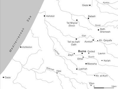
In the past 10 years, Faust has been excavated Tel 'Eton (usually identified with biblical 'Eglon; Josh 10; 15:39), a large site, about six hectares in size, located in the trough valley in the southeastern sector of the Judean Shephelah, just below the Hebron Hills (ca. 11 km east-southeast of Lachish; Fig. 1). The site was divided into 39 subunits, each of which was surveyed individually by about 10 surveyors. At the whole site, the surveyors collected 693 identified diagnostic sherds,[1] from the Early Bronze until the Byzantine and Early Islamic periods, the vast majority belonging to the Iron Age II. In addition to the survey, Faust and Katz excavated 38 1X1 m test pits all over the site, and collected a total number of 86 identified sherds, dating from the Late Bronze-Iron Age I to the Late Hellenistic periods. The vast majority of the sherds are dated to the Iron Age II. Faust and Katz compared these results with the results of the excavations at the site and concluded that while the detailed survey and shovel tests seem to give a reasonable picture of periods of occupation at the site, there is no precise way to calibrate the finds to reflect changes in the size of the site through time (Faust and Katz 2012).
SURVEYING TEL BURNA – METHODS AND RESULTS
The second and current study, that of Tel Burna, began in 2009, and is still underway. Tel Burna is located in the Judaean Shephelah, along the northern banks of Wadi Guvrin, slightly north of Lachish (Fig. 1). According to the 2009 survey (Uziel and Shai 2010), the site was established in the Early Bronze Age and settled intensively in the Middle and Late Bronze Ages and in the Iron Age.
Tel Burna was chosen for its suitability to the project’s goals, in an effort to draw conclusions regarding the pros and cons of the various methods and their applicability to tel sites. The aim of the study is to further develop survey methodology and tools in order to improve their quality and reliability as an archaeological technique and in order to promote this type of field work in the southern Levant. The site is a multi-period settlement, yet not of a size that would make it difficult to collect and process the data. The visibility of architectural features on the surface made it possible to use a survey for dating such features. By conducting both the surface collection and test pits prior to the excavation of any given area (see below), the study would not suffer from any bias in analysis of the data collected in the different methods of survey.
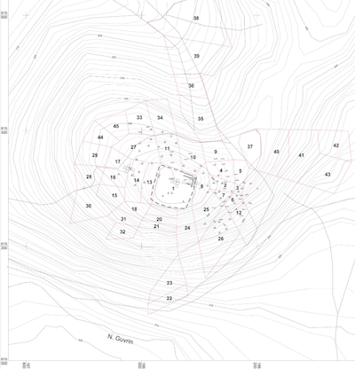
Tel Burna, showing the
location of the survey
fields, test pits and
excavation areas.
The survey was conducted over a 15-day period. The site was divided into 45 survey fields on the basis of topographic, geographic and architectural boundaries and features (Fig. 2). Six to ten surveyors walked at an arm’s-length distance from one another, in a straight line, across each field. In order to determine the extent of the site, the survey continued to collect artefacts wherever they were found. Once an empty field was defined, it was determined that the site did not extend to that point. By putting together the various fields dating from a certain period, maps were created, showing the distribution of the artefacts from that period.
A total number of 11,809 pottery sherds were collected over an area of 16 hectares. The distant fields yielded very little pottery, leading us to believe that the settlement only covered 10 hectares. Of all of the sherds collected on the surface, only 681 were diagnostic (5.8%; for a complete breakdown of the identification of diagnostic sherds,). Of these, it was possible to chronologically assign 570 pieces (84%). The finds allowed for the definition of significant periods of settlement in the Early Bronze Age III, Middle Bronze Age IIB, Late Bronze Age II, Iron Age I and Iron Age II. While other periods were represented sparsely (Early Bronze Age I, Intermediate Bronze Age, Persian, Hellenistic and Roman-Byzantine), nothing could be said of the nature of the settlement in these periods. Thus far, the results of the excavations and the test pits seem to support the estimates of settled area that were presented using the surface survey.
The excavation of test pits began in 2010, prior to excavation, and continues every season. To date, a total of 87 test pits have been excavated throughout the site (Fig. 2). The circular test pits (diameter: 1 m; excavated to a depth of 30 cm)[2] were distributed at random, several in each of the survey fields. The test pits have thus far been limited to the upper tel and its immediate slopes, in order to allow direct comparison with excavation data (see below). The contents of all test pits were fully sifted, in order to remove any bias based on preference of pottery types (e.g., decorated pottery, larger sherds). In all, 5,076 sherds were collected, 412 of which were identifiable (8.1%). While this is a relatively small sample of sherds — particularly when considering each pit on its own — the combination of data from several pits in a given survey field increases the number of sherds in each area.
As the test pits did not include the entire area covered by the surface survey, it is too early to determine the size of the site on the basis of the distribution of artefacts in the pits. However, a few points can be made regarding the area covered. First, the early periods detected in the survey (EB III, MB II) do not appear in the test pits except as stray sherds. Consequently, no solid conclusions can be reached regarding artefact distribution for these periods — in contrast to the surface survey. Second, the two dominant periods represented are the Late Bronze Age and Iron Age II, like in the surface survey. This clearly indicates the intensive settlement on the site in these periods, also noted in the surface survey. Finally, in contrast to the surface survey, where Byzantine sherds were scattered in small amounts in different areas of the tel, the test pits yielded Byzantine pottery almost exclusively from the eastern slopes (Fields 2, 3, 6, 7, 8, 12;), where the lines of walls of a large building are visible on the surface. The visible architecture relating to this building, suggest a post-Iron Age date for this building.
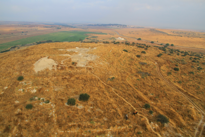
western slopes Tel Burna,
where a large building can be
seen on surface
The excavations thus far have revealed information on two areas — the summit (Areas A1, A2 and B2) and the western slope (Area B1), chosen after studying the results of the surface survey. On the summit (corresponding to survey fields 1 and 8; test pits 2–8, 21, 22, 23, 37), the documented strata spanned the Iron Age IIA to the Persian period, including the fortifications of the upper tel (see also Shai et al. 2012). In Area B1 (corresponding to survey fields 13, 14, 16, 17; test pits 9–15), part of a large Late Bronze II building was uncovered, built directly on bedrock (Fig. 3; Shai, Mckinny and Uziel 2015). In this area 32% of the surface artefacts are dated to this period. In addition, EB, MB, Iron II and post-Iron pottery were well represented. The test-pit results are no clearer. While there is no representation of the Early or Middle Bronze Age and hardly any post-Iron Age pottery (only a single sherd), the LB pottery presents one-third of the finds, the other two-thirds dating from the Iron Age II. Therefore, while the test pits filtered out most of the periods not revealed in the excavations, the Iron Age II was strongly represented, probably as a result of erosion from the upper tel down the slope (as Area B1 is located below the summit, at the foot of a steep slope) and due to the fact that this was the last period of heavy inhabitation of the site.
This reflects the understanding that the test pits better represent the uppermost and more dominant strata, while removing ‘noise’ such as later pottery, which reflects transient human activity, rather than an actual archaeological stratum on the upper tel and the western slope. In this sense, it seems that the test pits also pinpointed the actual area of post-Iron Age activity along the eastern slopes. This will hopefully be corroborated through further excavation. That said, the test pits showed little indication of the presence of earlier settlements, such as the Early and Middle Bronze Ages, which were strongly represented in the surface survey, and likely have significant strata buried below the Late Bronze and Iron Age settlements.[3] In this sense, the surface artefact collection proved crucial. It seems, therefore, that a combination of the two methods of survey may be optimal in obtaining an accurate picture: presenting the maximal representation of periods (surface artefact collection) and refining it through the use of test pits.
Comparing our study of Tel Burna with the study conducted at Tel 'Eton, some methodological issues are clarified. The amount of test pits is directly connected to the size of the sample. More than twice as many test pits were excavated at Tel Burna than at Tel 'Eton, while the area in which they were spread was six times smaller.[4] There is a need to correlate between the number of test pits and the area covered, as too few pits will not provide a proper data-set for study. While Faust and Katz suggested using larger test pits (at least 2×2 m) in order to yield sufficient data from each pit for analysis, we believe that a spread of several pits in a given survey field — as applied at Tel Burna (where four pits were excavated in each survey field)—will yield a larger data-set of diagnostic sherds while also providing more randomality in the location of the pit, thus generating more diversity in the diagnostic sherds.
THE REGIONAL SURVEYS
Regional surveys are very common in Israel and the southern Levant. Since the pioneering work of Nelson Glueck in the Jordan valley on the middle of the 20th century, regional surveys was made in almost every region - The Galilee, the Negev, the Sinai peninsula, Judea and Samaria, the Shephelah, etc. In this kind of survey, dozens of sites are surveyed, not enabling the conducting of a thorough and punctilious investigation of each site, as can be done on a single site survey project. However, when examining the settlement history of an entire region, one can assume that a reliable general picture can be drawn, even though the data for a single site can be somewhat biased. Moreover, drawing a regional settlement picture according to a few excavated sites in the region, without using regional survey study, can lead to erroneous conclusions as most of the data necessary for developing regional settlement patterns remains hidden, with only choice sites excavated.
Although the working premise in all regional surveys is identical, none of the surveys is similar by method, intensity, manner of publication, and conclusions. One of the most comprehensive methods is the intensive foot survey, where an entire region is surveyed by foot, meter after meter, with the purpose of finding sites, features and artifacts. As this method requires a huge effort and vast resources, other, less time- consuming methods, were developed - the random survey, the semi-random survey (e.g. Barker 1991, 3-4) or sites' survey, focused only on known sites from earlier research (e.g. the Judean Hills Survey, Ofer 1993). In recent years, more methods are being used in regional surveys, such as integrating test-pits at some sites (Leibner 2009) and using aerial, satellite or Infra-Red photos (e.g. Kennedy 1998; Pixler 2001; Wilson 2003; Richardson and Hritz 2007).
The use of regional surveys as a source of reconstructing the settlement history of regions in the Levant raised some questions and doubts over its value (see e.g. Faust and Safrai 2005, 149-153). First, in most of the surveys there is a lack of distinguishing between periods. In various surveys, one can find the definitions 'Middle Bronze', Iron II', 'Hellenistic' ‘Roman- Byzantine’, 'Middle Ages' etc. without the sub-divisions of these periods. This is due to the nature of the ceramic sherds collected on surveys, mostly worn and which cannot be identified accurately, and because of the lack of pottery assemblages, which assist in creating a complete chronological picture. Second, different surveys conducted at the same sites by different teams yielded different results, and at times also differed from archaeological excavations undertaken later at the same sites. However, we must notice that incidental mistakes on the level of the individual settlement will be ‘repaired’ in the general analysis.
THE NEW SOUTH SAMARIA SURVEY – A NEW APPROACH FOR REGIONAL SURVEYS
In order to overcome these methodological problems, we wish to present a different approach to the value of regional surveys. Indeed, regional survey by itself cannot produce a complete historical picture of a region. For such a task to be completed, integration with excavation results and historical sources (at least for periods with relevant sources) is needed. Nevertheless, other goals can be achieved from such field work, thus affecting the methods that should be used. For the sake of demonstrating this approach, the methods and initial results of the New South Samaria Survey will be presented below. The project is currently being undertaken as a joint research project of the institutes of archaeology of Ariel and Bar-Ilan Universities and the Staff Officer Unit of archaeology of Judea and Samaria.
The region of South Samaria is situated on the hill county north of the Land of Benjamin and south of the Shechem Syncline. The settlement pattern of this region in all periods is of rural nature, due to the topographic conditions of high hills and steep and deep valleys. The main sites, known also from historical sources, are located along the main road that crosses the region, such as Tel en-Nasbeh, Bethel and Shiloh. Previous archaeological explorations in this region were conducted during the 20th century, including excavations of only a few sites, and some surveys undertaken in 1968 and in the early 1980’s (Gofna and Porat 1971; Kallai 1971; Feldstein et al. 1993; Hizmi 1993; Finkelstein, Lederman, and Bunimovitz 1997). Each of these surveys has its disadvantages. In the "Emergancy Survey", conducted right after the Six Day War, much information was gathered, but due to its hasty nature, many sites were skipped and the ceramic finding weren't studied in detail. In Dar's survey of the northwestern part of the region, there was a lack of organized data about the inhabitation periods of the sites, and there is only sparsely documentation about the artefacts that were collected. The thorough survey of the region directed by Finkelstein, Lederman and Bunimovitz visited almost all of the marked archaeological sites and Arab villages, and covered most of the area with an intensive foot survey. However, the main goal of their survey was to obtain an historical picture of the inhabitation periods of the sites by collecting pottery, and little concern was given to other remains, such as caves, underground features and structures.
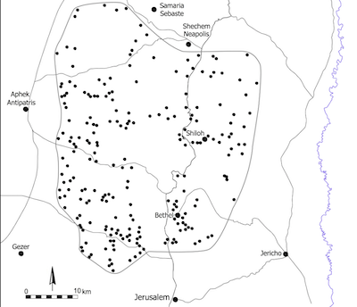
South Samaria Survey Project
Since 2014, the New South Samaria survey has been undertaken. The method of the survey used in this project is a "high-resolution sites' survey". In this project, more than 200 of the sites that had been surveyed in the past are being re-surveyed (Fig. 4). The sites were chosen according to different methodological criterion and due to research questions and limitations of time, security and political situation, leaving about 60% of all the known sites of the region for surveying, with the addition of a few new discovered sites. The goal of this kind of survey is not only to reveal the occupation periods of the sites, data that is already known from the previous explorations, but to retrieve as much archaeological information as possible at each site in order to better understand the material culture of this region in various periods. For the sake of reaching this goal, much more time is spent in the intensive survey of each site, including drawing plans of architectural remains, caves, installations and underground hewn complexes, documenting every element using GPS marks and drawing a major plan for each site using a GIS system. Such an intensive survey often also yields a large amount of pottery sherds of a variety of types. These finding, when compared with assemblages from excavated sites in the environs, can assist in meticulous research regarding the ceramic typology of this region.
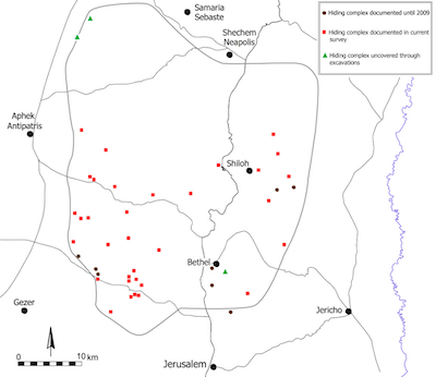
Hiding Complexes
One example from the results of the first two years of this project can demonstrate the importance of such survey and the contribution of it to the historical and archaeological research of the region. Until recent years, the extent of the Jewish revolts against the Romans was considered by scholars as being held only south, east, and west of Jerusalem, but not north of it (see e.g. Kloner and Zissu 2003). The archaeological evidence for the Bar-Kokhba Revolt in these regions included refugee caves, hiding complexes and coins. In the new South Samaria survey, dozens of typical underground hiding complexes, with pottery from the Early Roman period, were found as a result of the intensive survey at many sites of this area, from the dessert fringe in the east to the foothills to the west. In earlier surveys at the same sites there was not even a single mention of it, as in these surveys no concern was given to the architectural remains and to the hewn complexes. Many of these complexes were uncovered due to the dense looting of sites in the past. Almost all the sites in these regions suffer from intensive destruction by antiquities robbers over the past thirty years, including digging and looting ancient finds, while at the same time they also expose many remains (mainly caves and underground complexes) that were covered until their work. An in-depth examination of the pottery found at these sites, compared to excavated sites from the Early Roman period shows that most of these complexes can be dated to the Bar-Kokhba Revolt era. These results shed light on the expansion of the Bar-Kokhba Revolt to the north (Fig. 5).
One should note that such a survey cannot provide statistical data, and this is not one of its goals. First, as it is not a meter-by-meter survey, one cannot refer to the data about the occupation periods of the sites from this survey as representing the whole region's history. The artefacts and other findings clearly represent the material culture of the different periods, but not with statistical value. Even when analyzing each site on its own, we must be very cautious when trying to reconstruct the site's size in different periods according to the percentage of the pottery sherds. As opposed to a single site survey and test pits method, the number of sherds collected at one site in regional surveys, even in intensive ones, is not large enough to make such conclusions. In the previous survey of South Samaria, Finkelstein, Lederman and Bunimovitz calculated the site's size of each period as a reflection of the percentage of identified sherds from these periods collected at sites. The new survey has proven this is a wrong assumption, as the percentages from the various periods in many sites differ from Finkelstein's Data.
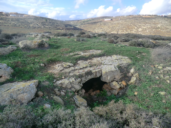
unnamed site (near Kh. el-Marjim) Dated to the
Persian Period
Nevertheless, there are several cases where despite the problematic nature of comparing the percentage of sherds between periods, certain conclusions can be reached regarding the site's size. One example emphasizes this and can demonstrate the value of the intensive survey even from a statistical aspect. In the desert fringe, south of the village of ed-Duma, there are three sites at a distance of approximately 1.5 KM from each other – Kh. Jib'it, Kh, el-Marjim and an unnamed site. Kh. Jib'it is the largest (about 5 hectares), and in both surveys a sum of 203 sherds from the Iron Age II were collected and only 13 sherds from the Persian period. At Kh. el-Marjim 316 sherds from the Iron Age II were collected in both surveys and only 4 sherds from the Persian period. Such differences between the periods cannot be a bias or a methodological mistake, and it is quite safe to make the historical assumption that these two sites were inhabited during the Iron Age II, and were abandoned at some point before the Persian period, or inhabited sparsely. On the other hand, at the nearby unnamed site, in both surveys only several sherds from the Iron Age were collected, but more than 60 sherds from the Persian period were found. In addition to the pottery collection, an intensive survey was conducted at the site on December 2014, showing that not even a single building can be traced at this site and at least 7 living caves were documented (Fig. 6). Therefore, it seems that the settlement type changed from large inhabited sites in the Iron Age II to a cave settlement in the Persian period, a settlement type that is well known in other areas in the desert fringe (Peleg 2012). This example shows that using the method of the intensive sites' survey one can collect crucial data both from the nature of the site, as seen at the site's plan, and in rare cases also from the percentage of the pottery sherds.
CONCLUSIONS
The study of different methods of survey at a multi-period site is ongoing, and it is hoped that more studies like the present one will help advance survey methodology in general and in the southern Levant in particular. From our work at Tel Burna, it seems that the best approach to surveying a tell-site would combine surface artefact collection with the use of test pits, in order to integrate the results and draw conclusions regarding the settlement history of a site. Whereas this study is just a small step in improving the methods of survey used in ‘tel research’ — particularly regarding the art of surveying, the application of this and other methods in an increasing number of projects and discussion on the improvement of these methods will lead to the further advancement of the methodology used in non-destructive archaeological research. We believe that the new approach to the regional surveys with setting up new goals, as done in the New South Samaria Survey, will improve results and will lead to developments of new methods. This is of much importance as the role of survey in archaeological studies was, is and will be major in order to gain a wide picture of material culture and settlement patterns in antiquity.
Acknowledgements
Funding for the project was provided by Ariel University and the Samaria & Jordan Rif R&D Center. Plans and maps of Tel Burna were prepared by J. Rosenberg.
REFERENCES
Adan-Bayewitz, D.
2003 On the Chronology of the Common Pottery of Northern Roman Judaea/Palestine. In: Bottini, G.C., Di Segni, L. and Chrupcala, L.D. (eds.), One Land—Many Cultures: Archaeological Studies in Honour of S. Loffreda. Jerusalem: 5–32.
Barker, G.
1991 Approaches to Archaeological Survey, In: Barker, G. and Lloyd, J. (eds.), Roman Landscapes – Archaeological Survey in the Mediterranean Region, London: 1–24.
Dagan, Y.
2000 The Settlement in the Judean Shephelah in the Second and First Millennium B.C.: A Test-Case of Settlement Processes in a Geographic Region (unpublished Ph.D. diss., Tel Aviv University; Hebrew).
2009 Khirbet Qeiyafa in the Judean Shephelah: Some Considerations, Tel Aviv 36: 68–81.
Faust, A. and Katz, H.
2012 Survey, Shovel Tests and Excavations at Tel ªEton, Tel Aviv 39: 158–185.
Faust, A. and Safrai, Z.
2005 Salvage Excavations as a Source for Reconstructing Settlement History in Ancient Israel, PEQ 137: 139–158.
Feldstein, A., Kidron, G., Hanin, N., Kamaisky, Y. and Eitam, D.
1993 Southern Part of the Maps of Ramalla and el-Bireh and Northern Part of the Map of Ein Kerem, In: Magen, Y. and Finkelstein, I. (eds.), Archaeological Survey of the Hull Country of Benjamin, Jerusalem: 97–131 (Hebrew).
Finkelstein, I.
1997 Methods of the Field Survey and Data Recording, In: Finkelstein, I., Lederman, Z. and Bunimovitz, S. (eds.), Highlands of Many Cultures: The Southern Samaria Survey, Tel Aviv: 11–24.
Finkelstein, I., Lederman, Z. and Bunimovitz, S.
1997 Highlands of Many Cultures: The Southern Samaria Survey, Tel Aviv.
Garfinkel, Y. and Ganor, S.
2010 Khirbet Qeiyafa in Survey and in Excavations: A Response to Y. Dagan, Tel Aviv 37: 67–78.
Gofna, R. and Porat, Y.
1971 The Land of Ephraim and Manasseh, In: Kochavi, M. (ed.), Judaea, Samaria and the Golan, Archaeological Survey 1967-1968, Jerusalem: 195–241 (Hebrew).
Hayes, K.H.
2007 Field Excavations at Sylvester Manor, Northeast Historical Archaeology 36: 34–50.
Hizmi, H.
1993 Southern Part of the Map of Beit Sira, In: Magen, Y. and Finkelstein, I. (eds.), Archaeological Survey of the Hull Country of Benjamin, Jerusalem: 17–95 (Hebrew).
Kallai, Z.
1971 The Land of Benjamin and Mt. Ephraim, In: Kochavi, M. (ed.), Judaea, Samaria and the Golan, Archaeological Survey 1967-1968, Jerusalem: 151–193 (Hebrew).
Kennedy, D.
1998 Aerial Archaeology in Jordan, Levant 30: 91–96.
Kessy, E.T.
1997 Archaeological Sites Survey from Kisiju to Dar es Salaam, Nyame Akuma 48: 57–69.
Kloner, A. and Zissu, B.
2003 Hiding Complexes in Judaea: An Archaeological and Geographical Update on the Area of the Bar Kokhba Revolt, In: Schäfer, P. (ed.), The Bar Kokhba War Reconsidered, New Perspectives on the Second Jewish Revolt against Rome, Tübingen: 181–216.
Lebeau, M.
1997 La situation géographique, la topographie et les périodes d’óccupation de Tell Beydar, In: Lebeau, M. and Suleiman, A. (eds.), Subartu III. Tell Beydar, Three Seasons of Excavations (1992–1994). A Preliminary Report, Brepols: 7–17.
Leibner, U.
2009 Settlement and History in Hellenistic, Roman, and Byzantine Galilee: An Archaeological Survey of the Eastern Galilee. Text and Studies in Ancient Judaism, Tübingen.
Ofer, A.
1993 The Highland of Judah during the Biblical Period (unpublished Ph.D. diss., Tel Aviv University; Hebrew).
Peleg, Y.
2012 Iron Age Cave Settlements in the Land of Benjamin's Frontier Desert, Judea and Samaria Research Studies 21: 23–33 (Hebrew).
Pixler Y.
2001 Mapping and Aalysis of Roman Roads in Palestine Based on Aerial Photographs (unpublished Ph.D. diss., Bar-Ilan University; Hebrew).
Portugali, Y.
1982 A Field Methodology for Regional Archaeology (The Jezreel Valley Survey, 1981), Tel Aviv 9: 170–188.
Richardson, B.F. and Hritz, C.
2007 Remote Sensing and GIS Use in Archaeological Analysis of the Central Mesopotamian Plain, In: Weisman, J. and el-Baz, F. (eds.), Remote Sensing in Archaeology, New York: 283–325.
Shai, I., Cassuto, D., Dagan, A. and Uziel, J.
2012 The Fortifications at Tel Burna: Date, Function and Meaning, IEJ 62: 141–157.
Shai, I., Mckinny, C. and Uziel, J.
2015 Late Bronze Age Cultic Activity in Ancient Canaan: A View from Tel Burna, BASOR 374: 115–133.
Shai, I. and Uziel, J.
2014 Addressing Survey Methodology in the Southern Levant: Applying Different Methods for the Survey of Tel Burna, Israel, Israel Exploration Journal 64: 172–190.
Shavit, A.
2008 Settlement Patterns of Philistine City-States, In: Fantalkin, A. and Yasur-Landau, A. (eds.), Bene Israel: Studies in the Archaeology of Israel and the Levant during the Bronze and Iron Ages in Honour of Israel Finkelstein, Leiden: 135–164.
Shenkman, Y.
1999 Excavation Survey as a Method for Clarifying Settlement History: Kefar Hananya as a Case Study (unpublished M.A. thesis, Bar-Ilan University; Hebrew).
Stoetzel, J.
2011 Field Report: Archaeological Survey of Songo Mnara Island, Nyame Akuma 76: 9–14.
Ussishkin, D.
2009 On the So-called Aramaean ‘Siege Trench’ in Tell es-Safi, Ancient Gath, IEJ 59: 137–157.
Uziel, J.
2003 The Tell es-Safi Archaeological Survey (unpublished M.A. thesis, Bar-Ilan University).
Uziel, J. and Maeir, A.M.
2005 Scratching the Surface at Gath: Implications of the Tell e-Safi/Gath Surface Survey, Tel Aviv 32: 50–75.
Uziel, J. and Shai, I.
2010 The Settlement History of Tel Burna: Results of the Surface Survey, Tel Aviv 37: 227–245.
Wilkinson, T.
1989 Extensive Sherd Scatters and Land-Use Intensity: Some Recent Results, Journal of Field Archaeology 16: 31–46.
Wilson, D.R.
2003 Air-Photography and Aenta Icenorum, In: Wilson, P. (ed.), The Archaeology of Roman Towns: Studies in Honor of John S. Wacher, Oxford: 251–257.
Notes
[1] The term ‘diagnostic’ here refers to rim fragments and not decorated sherds, to avoid bias of given periods due to the decoration of body sherds. For example, the identification of body sherds of the Iron Age II is easier than that of the Bronze and early Iron Ages, due to the extensive use of slip and burnish. That said, while this pottery was not taken into account in the quantitative analysis, it was not disregarded in terms of surface scatter, as this would be ignoring data that could help reconstruct the site’s history.
[2] The number of test pits dug in each survey field varied according to the size of the field and its topographic nature.
[3] Even though such strata have not yet been exposed, residual sherds found in the excavation suggest their presence beneath the Iron Age city.
[4] At Tel Burna the 87 test pits were spread only over the summit and the terraces directly below it, an area of c. 1 hectare, while at Tel 'Eton the 38 test pits were excavated over the entire site, i.e. six hectares.