Large Cult Complex Dating to the 13th Century BCE has Been Discovered at the Site of Tel Burna in Israel.
By Chris McKinny
Bar Ilan University
By Deborah Cassuto
Bar Ilan University
Ernest S. Frerich's Fellow
By Itzhaq Shai[1]
Ariel University
Director, Tel Burna
April 2015
Introduction
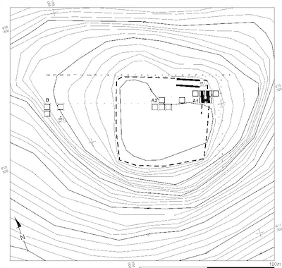
Tel Burna is located in the Judean Shephelah on the northern bank of the Nahal Guvrin and is surrounded by archaeological tells which have long been a focal point of interest for archaeologists and historical geographers of the Bronze and Iron Ages in the southern Levant.
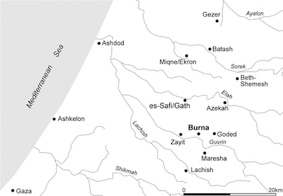
location of the site and nearby
sites.
From the end of the 19th century C.E., there have been numerous excavations carried out throughout the region including the current expeditions at the sites of Gezer, Beth-Shemesh, Tell es-Safi/Gath, Azekah, Maresha, Lachish, and Tel ‘Eton. Interestingly, despite the extensive amount of research in the Judean Shephelah, Tel Burna had remained unexcavated until our project began work in 2009. From our preliminary survey (Uziel and Shai 2010; cf. Shai and Uziel 2014), it became evident that the Late Bronze and Iron Ages would be well represented at the tell. The subsequent six seasons of excavation have supported this initial impression by exposing ample evidence of occupation during these periods. The nature of the material excavated at Tel Burna places it well within the Late Bronze Age and Iron Age landscape of the region.
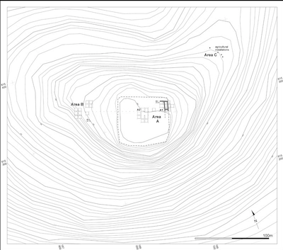
This paper provides an overview of the findings of the first six seasons of excavation at Tel Burna during which our work has focused on three areas of the tell: Area A1- an east-west section at the northeastern corner of the tell, Area A2 - at the center of the summit, and Area B - a lower shelf on the western side of the tell.
Thus far, we have excavated strata dating chronologically from the Late Bronze Age IIB (13th century B.C.E.), the late Iron Age IIA (9th century B.C.E.), the Iron Age IIB (8th century B.C.E.), the Iron Age IIC (7th century B.C.E.), and the Persian Period as well as encountering artifacts from the Early Bronze, Middle Bronze, Iron I, and Byzantine periods in un-stratified contexts. In this report, we will briefly discuss the excavated strata by providing a preliminary analysis of their architectural remains. These remains include a large Late Bronze Age public building and courtyard in Area B, Iron Age II fortifications and silos in Area A1, and a large Iron Age II four-room house in Area A2.
The Late Bronze Age
Area B.
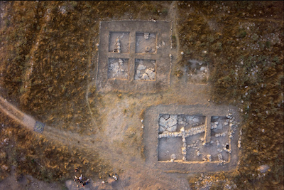
In Area B, a portion of a large 13th century B.C.E. structure was uncovered only a few centimeters below the surface. Thus far, only part of this building has been excavated and the plan of the building is yet unclear, however, its size and construction technique clearly indicate that this was not a common domestic building. The bedrock in the large courtyard (16x16 m) is high and appears to have served as a surface in several places; while in other parts of the courtyard, there are indications that the inhabitants intentionally filled in the uneven gaps of the bedrock to create a larger flat surface. Three Cypriot votive vessels were placed on a flattened stone, which was located where the bedrock had a natural protruding hump. Other finds include a scarab alongside numerous beads, a cylinder seal, a rich ceramic assemblage of both local and imported pottery and many animal bones. Cultic activity in the courtyard can be inferred by the presence of numerous goblets and chalices (often associated with feasting activities), several Cypriot zoomorphic vessels (possibly for libations), local and imported (Cypriot and Mycenaean) figurines and the fragments of two distinct ceramic masks. One can also note the presence of two huge imported Cypriot pithoi each with a capacity of c. 200 liters! Based on ceramic analysis this large public structure can be dated to the 13th century B.C.E. Taking in account the building's size, the noticeable effort invested in its construction, as well as the cultic/ritualistic vessels discovered within its confines, our present interpretation of the structure is a large Late Bronze Age center for cultic activities.
The Iron Age II and the Persian Period
During the Iron Age II, Tel Burna was an integral part of the Judahite fortification line along its western border. Casemate fortifications can be seen directly on the surface of the upper tell and have been noted as far back as the mid-19th century (McKinny and Dagan 2013). In Area A1, we have exposed a section of these fortifications at the northeastern corner of the upper tell. Taking into account the excavated portion and the observed remains on the surface of the tell the length of the entire fortification was c. 280 m, which formed a square area of c. 70x70 m
casemate wall.
The parallel walls of the fortification were constructed of large field stones preserved to a height of c. 2 m.; the casemate fortification is c. 5.5 m. thick with an outer wall c. 2 m thick, a gap of c. 2 m, and an inner wall of c. 1.5 m (cf. Shai et al. 2012:143–146).
Inside of the fortifications, our excavations revealed a series of strata from the 9th century until the 7th century B.C.E. (i.e. late Iron Age IIA-Iron Age IIC) (Shai et al. 2012). While it is too early to date the initial construction of these fortifications, our progress thus far indicates that they were clearly in use from the 9th century B.C.E. (e.g. similar to the assemblages of Lachish levels V-IV - Zimhoni 2004a; Tell es-Safi/Gath stratum A3 - Shai and Maeir 2012). Future excavations of the fortifications are expected to determine the period of their construction. In addition to the in situ late Iron Age IIA remains found inside of the fortified walls, we also exposed a surface with restorable late Iron Age IIA vessels outside of the walls. This indicates that the 9th century B.C.E. the inhabitants of Tel Burna were both using the fortifications for protection, while simultaneously living outside of the walls.[2]
The 8th century B.C.E. (Iron Age IIB) is the next phase in Tel Burna’s occupational history. Like many sites in the Judean Shephelah (e.g. Dagan 2006:36*–37*), Tel Burna seems to have experienced a period of prosperity due to favorable geo-political conditions caused by the collapse of Philistine Gath and the presumed western expansion of Judah during the reigns of such monarchs as Uzziah and Hezekiah (e.g. Zukerman and Shai 2006; Maeir 2012; Dagan 2014). This expansion is mentioned directly in the biblical narrative (2 Kings 18:8; 2 Chron. 26:6), but is also implied in the late 8th century B.C.E. Neo-Assyrian “Azekah Inscription,” which indicates that either Sargon or Sennacherib destroyed “the city of x, a royal city of the Philistines, which Hezekiah had taken and fortified for himself” (lines 10-12; Cogan 2008:108 COS 2.304-305). This historical reality can be observed in the rich 8th century B.C.E. stratum at Tel Burna, which has been the dominant sub-period of the Iron Age II in every excavated square inside the fortifications.
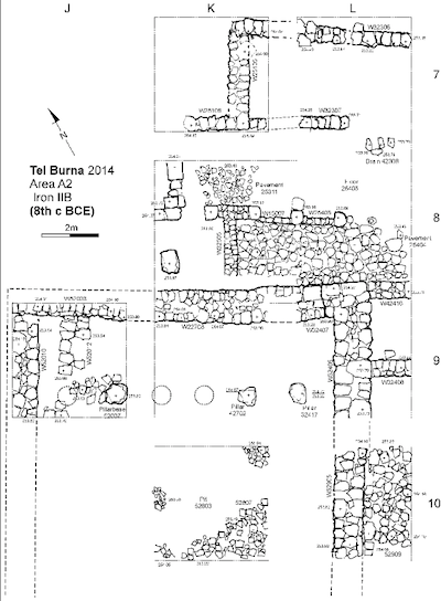
Room House.
Additional 8th century remains were found in Area A2 on the summit. Here we revealed a large public complex comprised of a paved courtyard just north of a large four-room house. In the northwest corner of the northern room of the four-room house, smashed vessels were discovered buried below an accumulation of destruction debris. These vessels represent the horizon of the end of the 8th B.C.E. (e.g. similar to Lachish level III - Zimhoni 2004b), which makes it tempting to associate the destruction with Sennacherib’s campaign (701 B.C.E.), keeping in mind that it is too early at this stage in the excavations, to determine if this was merely a local event or something more elaborate. Among the typical 8th century B.C.E. pottery wares, we found several stamped jar handles including some with the LMLK type seal impressions and one with a private or official seal bearing the names לעזר/חגי (to Ezer son of Haggi) (Shai et al. 2014). It should be noted that, thus far, this building has only been partially exposed but a few points can already be highlighted:
-
The location of the four-room house inside the fortified area, the building's size, and construction technique, as well as the discovery of a LMLK stamped handle, indicate that this was a public or an elite building (e.g. Barkay and Vaughn 1996; Lipschits et al. 2010, 2011).
-
The pottery assemblage is of the typical end of 8th century B.C.E. repertoire and is very similar to Lachish Level III.
-
Several pillar figurines, typical to the Judahite population, were discovered in this building (Kletter 1996).
-
To date, we have yet to uncover evidence for the type of large-scale destruction that one would expect for a site that would have fallen in Sennacherib’s campaign (e.g. the destruction of Level III at Lachish).
Above the 8th century B.C.E. level we consistently found a scanty 7th century B.C.E. (Iron Age IIC) stratum whose inhabitants seem to have often used the ruins of the previous level in their buildings. This Iron Age IIC re-use is especially marked by a considerable number of silos that were excavated in both the fortifications of Area A1 and in the ruins of the large complex of Area A2 on the summit. Of special import is the presence of a silo in the inner casemate wall which was formed by removing the wall's stones in order to create a circular depression. The removal of these stones clearly weakened the wall and indicates that by that time the inner fortification, if not the entire fortification, was no longer in use after its destruction in the 8th century B.C.E.
Remains from the Iron Age IIC period are marked by typical Judahite wares (e.g. similar to Lachish level II - Zimhoni 2004b) and several rosette seal impressions. The latter is widely understood as a successor to the earlier LMLK seal impressions, as they are thought to have served a similar administrative purpose (e.g. Cahill 1995; Koch and Lipschits 2013). These impressions together with the architectural remains indicate that in the 7th century B.C.E. Tel Burna remained under Judahite administrative control. In this regard, the fate of the site paralleled that of the Shephelah as a whole which reached its apex in number of inhabited sites in the 8th century B.C.E. before the devastation of Sennacherib’s campaign in 701 B.C.E. Following this destruction, the cities and towns of the Shephelah (including Tel Burna), began to recover until the Neo-Babylonian destruction of the Judahite state at the beginning of the 6th century B.C.E. This latter destruction is currently not traceable at Tel Burna, which may not have actually suffered a direct assault, however, the scanty remains of the Iron IIC followed by later Persian remains (e.g. fragments of Persian moratoria, Greek Attic ware, etc.) suggest that, for the most part, the summit and its fortifications were abandoned during this period.
Discussion
The Late Bronze Age public building at Tel Burna is an important discovery. Our continued exposure of the building will hopefully shed light on the specific practices carried out by the Canaanite inhabitants of Tel Burna, as well as to provide researchers with a point of comparison to similar structures, such as the nearby fosse temples at Lachish (cf. Tufnell et al. 1940; Koch 2014). While we have yet to uncover this period in other parts of the tell, the presence of Late Bronze Age activity in a public context (i.e. non-domestic) outside of the principal part of the tell would seem to indicate that the inhabitants of Tel Burna may have played an important role in the Late Bronze Age settlement of the Shephelah.
Later in the site's history, the large Iron Age II fortifications, the impressive public structures on the summit, and the numerous seal impressions indicate that Tel Burna was an integral part of Judah’s fortified western border. These features coupled with Tel Burna’s geographical location in the Nahal Guvrin (an important east-west route); near Lachish, the administrative capital of the Iron Age II Judean Shephelah; and its close proximity to the inner route of the International Coastal Highway, all suggest that the site was more significant than its size (10 hectares) might indicate. These realities along with various geographical and textual clues from the Bible have led several scholars to suggest that Tel Burna be identified with biblical Libnah (see Suriano et al. in press for discussion and extensive bibliography). This is an interpretation that our team has continued to maintain while bearing in mind other possible candidates that have been suggested by different scholars (e.g. Tel Zayit - Tappy 2011). Our continued excavation of the site is expected to provide us with more information regarding the biblical identification of Tel Burna, as well as, provide us with many new details regarding the Late Bronze Age and Iron Age inhabitants of the town.
Acknowledgments
The aerial photography was taken by SkyView; and the plans were prepared by J. Rosenberg.
Bibliography
Barkay, G., and A.G. Vaughn
1996 LMLK and Official Seal Impressions from Tel Lachish. Tel Aviv 23(1): 61–74.
Cahill, J.M.
1995 Rosette Stamp Seal Impressions from Ancient Judah. Israel Exploration Journal 45(4): 230–252.
Cogan, M.
2008 The Raging Torrent: Historical Inscriptions from Assyria and Babylonia Relating to Ancient Israel. Carta, Jerusalem.
Dagan, A.
2014 Between Judah and Philistia in the 8th century BCE: The Material Culture of Tell es-Safi/Gath as a Test Case for Political and Cultural Change. Unpublished Dissertation, Bar Ilan University, Ramat Gan.
Dagan, Y.
2006 Map of Amazya. 2 vols. Archaeological Survey of Israel 109. Israel Antiquities Authority, Jerusalem.
Koch, I.
2014 Goose Keeping, Elite Emulation and Egyptianized Feasting at Late Bronze Lachish. Tel Aviv 41(2): 161–179.
Koch, I., and O. Lipschits
2013 The Rosette Stamped Jar Handle System and the Kingdom of Judah at the End of the First Temple Period. Zeitschrift des Deutschen Palästina-Vereins 129: 55–78.
Lipschits, O., O. Sergi, and I. Koch
2010 Royal Judahite Jar Handles: Reconsidering the Chronology of the LMLK Stamp Impressions. Tel Aviv 37(1): 3–32.
2011 Judahite Stamped and Incised Jar Handles: A Tool for Studying the History of Late Monarchic Judah. Tel Aviv 38(1): 5–41.
Maeir, A.M.
2012 Philistia and the Judean Shephelah After Hazael: The Power Play Between the Philistines, Judeans and Assyrians in the 8th century BCE in Light of the Excavations at Tell es-Safi/Gath. In Disaster and Relief Management - Katastrophen und Ihre Bewältigung, edited by A. Berlejung, pp. 241–262. Forschungen zum Alten Testament 81. Mohr Siebeck, Tubingen.
McKinny, C., and A. Dagan
2013 The Explorations of Tel Burna. Palestine Exploration Quarterly 145(4): 294–305.
Shai, I., D. Cassuto, A. Dagan, and J. Uziel
2012 The Fortifications at Tel Burna: Date, Function and Meaning. Israel Exploration Journal 62(2): 141–157.
Shai, I., A. Dagan, S. Riehl, A. Orendi, J. Uziel, and M. Suriano
2014 A Private Stamped Seal Handle from Tel Burna, Israel. Zeitschrift des Deutschen Palästina-Vereins 130: 121–137.
Shai, I., and A.M. Maeir
2012 The Iron Age IIA Pottery Assemblage from Stratum A3. In Tell es-Safi/Gath I: Report on the 1996-2005 Seasons, edited by A.M. Maeir, pp. 313–363. Ägypten und Altes Testament 69. Harrassowitz, Wiesbaden.
Shai, I., and J. Uziel
2014 Addressing Survey Methodology in the Southern Levant: Applying Different Methods for the Survey of Tel Burna, Israel. Israel Exploration Journal 64(2): 172–190.
Suriano, M.J., I. Shai, and J. Uziel
in press In Search of Libnah. Journal of Near Eastern Studies.
Tappy, R.E.
2011 The Depositional History of Iron Age Tel Zayit: A Response to Finkelstein, Sass, and Singer-Avitz. In Amnon Ben-Tor Volume, 30:pp. 127*–143*. Eretz Israel.
Tufnell, O., C.H. Inge, and G.L. Harding
1940 Lachish (Tell ed Duweir) II The Fosse Temple. 2 vols. The Wellcome Archaeological Research Expedition to the Near East Publications. Oxford University Press, London and New York.
Uziel, J., and I. Shai
2010 The Settlement History of Tel Burna: Results of the Surface Survey. Tel Aviv 37(2): 227–245.
Zimhoni, O.
2004a The Pottery of Levels V and IV and its Archaeological and Chronological Implications. In The Renewed Archaeological Excavations at Lachish (1973–1994), edited by D. Ussishkin, 4:pp. 1643–1710. Monograph Series of the Institute of Archaeology of Tel Aviv University 22. Tel Aviv University, Tel Aviv.
2004b The Pottery of Levels III and II. In The Renewed Archaeological Excavations at Lachish (1973–1994), edited by D. Ussishkin, 4:pp. 1789–1899.
Zukerman, A., and I. Shai
2006 The Royal City of the Philistines in the Azekah Inscription and the History of Gath in the Eighth Century BCE. Ugarit-Forschungen(38): 729–816.
Notes
[1] The Tel Burna Archaeological Project is directed by Itzhaq Shai (Ariel University), assisted by Chris McKinniy (Bar Ilan University) and Deborah Cassuto (Bar Ilan University, and Ernest S. Frerich's Fellow, AIARI) as the supervisors of Area B and Area A respectively. The project is supported by the Israeli Ministry of Justice (קרן העזבונות) and private donors.
[2] We have noted that this phenomenon occurs on the eastern side of the tell, specifically the side which was not exposed to the border with Philistia.