
By Norma Franklin
The Zinman Institute of Archaeology
University of Haifa
By Jennie R. Ebeling
Associate Professor of Archaeology
University of Evansville
August 2013
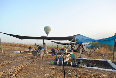
Balloon.
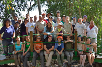
Co-directors Norma Franklin (University of Haifa) and Jennie Ebeling (University of Evansville) and approximately thirty-five staff, students and other team members from six countries participated in the inaugural season of excavation at Jezreel, Israel May 19-June 15, 2013. The Jezreel Expedition is co-sponsored by the University of Haifa and the University of Evansville, Indiana; Vanderbilt University and Villanova University are consortium members of the project. The Jezreel Expedition team is intent on exploring the history of occupation of “greater Jezreel” from late prehistory to the present, and architectural remains and artifacts from the Neolithic, Chalcolithic, Early Bronze Age, Iron Age, Byzantine and Ottoman periods were identified during four weeks of excavation.
Based on the results of a LiDAR aerial laser scan conducted in spring 2012 and a ground survey conducted in summer 2012 (http://www.bibleinterp.arizona.edu/articles/ebe368017), the Jezreel team focused on three excavation areas: on the northern edge of Tel Jezreel (Area M); at the foot of the natural hill of Jezreel (Area K); and on the eastern part of the uncultivated land – the masha – directly south of and above the spring of ‘Ein Jezreel (Area S). One of the main goals of the 2013 season was to test the LiDAR results in order to verify occupation on the terrace above ‘Ein Jezreel (Area S). Nehemia Zori (1977: 19, Site 33) identified architectural remains and abundant surface artifacts here, but no excavations had been conducted until this season (see further Ebeling et al 2012). Other goals were to explore areas of interest from the 2012 survey: an unexcavated area on the northern edge of the tel with exposed ashlar masonry attached to the bedrock and an impressive water cistern (Area M), and an agricultural installation located below the tel on the edge of an agricultural terrace (Area K). We met all of these goals during the four-week excavation season and are currently in the process of classifying the finds and analyzing our results. What follows is a brief preliminary report of the discoveries made in our three excavation areas in 2013.
Area M
Area M was chosen for excavation because of its partially-exposed bedrock surface with heavily eroded vestiges of monumental rock-hewn masonry located next to a large cistern and its strategic location. These features, recorded in our 2012 survey season as 12/M/15, are located on the northern edge of tel in an area unexplored by the Tel Aviv University – British School of Archaeology in Jerusalem (henceforth TAU-BSAJ) team during their excavations in the 1990s. This area offers a great panoramic view to the north of the tel stretching from the hills of Nazareth to the mountains east of the Jordan River.
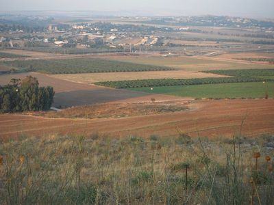
Valley from Area M.
However, unlike at other locations on the tel, the Jezreel Valley floor can also be clearly seen from this point; in ancient times, it would have allowed an unobstructed view of the east-west Via Maris/Way of the Sea from Megiddo to Bet Shean and the junction of the main north-south highway (the Way of the Patriarchs) that branched south here to Samaria and Jerusalem.
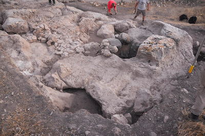
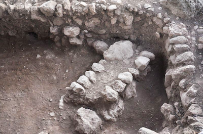
Ashlars.
The excavation team in Area M was led by Dr. Deborah Appler of Moravian Seminary and Dr. Philippe Guillaume of the University of Bern. The earliest and most conspicuous feature in the area is a large, bottle-shaped cistern surrounded by rock-hewn masonry that formed a large rectangular room or complete building (Room M1) measuring ca. 11.50 by 4.50 meters. A large cone of washed-in debris can be seen inside the cistern at a depth of four meters; the actual depth of this cistern is unknown (similar cisterns at other sites can be as deep as 15 meters). Two rectangular hewn blocks had been left attached to the bedrock and framed the cistern on its north and east sides; their appearance mimics ashlar masonry of the Iron Age II. Two more heavily eroded ‘false’ ashlar blocks were located ca. seven meters to the west of the cistern and other ‘false’ ashlars that were severely damaged by later building activity were documented southwest of the cistern. These pairs of ‘false’ ashlars were separated by a bedrock space or ‘negative’ ca. 80 cm wide that had been prepared to receive true ashlar masonry. Toward the western end of the room is a circular rock-cut shaft that we originally thought to be another cistern. After partial excavation, it proved to be a man-made entrance to a large cave or cave complex whose main entrance is cut along the rock-face of the north-facing scarp that forms the edge of Room M1. Although the cave was known to the builders of the room, there were many signs that it had been enlarged and altered in later periods.
The location of Room M1 provides us with a clue to its function. Its strategic position at the edge of the tel provides it with a commanding view over the valley below and the ancient highway that ran through it. In addition, the room had an internal water supply and a cave complex beneath its floor that would have provided excellent storage facilities. But what is the date of Room M1? No in situ pottery or clean loci could be associated with it because of the later use and alteration of this area and heavy erosion due to its exposed position. However, there are strong architectural parallels between Room M1 at Jezreel and the famous palace of Ahab and Jezebel at Samaria, which is also located on the edge of a scarp, features internal cisterns and caves and offers a magnificent view. Samaria (biblical Shomron) is located approximately 50 kilometers south of Jezreel and has connections to Jezreel during the Iron Age. Both Samaria and Jezreel have extensive agricultural installations dating to the Iron Age (see description of Area K below and Ebeling et al. 2012) and Samaria has well-documented monumental rock-hewn architecture, numerous bottle-shaped cisterns and enigmatic cave complexes. Based on what we know of the Iron Age II at Jezreel and the architectural techniques associated with this period, it appears that Room M1 should be attributed to the earliest phases of the Iron Age II present at Jezreel. This phase correlates with the Omride palace at Samaria (Building Period I , 9th c BCE) while Jezreel’s enclosure phase as revealed by the TAU-BSAJ team correlates with the enclosure at Samaria (Building Period II , 8th c BCE) (Franklin 2008; for an alternative date see Ussishkin and Woodhead 1992: 53). Later alterations to this area appear to be late Byzantine or immediately post-Byzantine as they were sealed below deposits of late Byzantine pottery and a wine pressing installation from this period was previously excavated just south of Area M (Moorhead 1997: 142-143, Figure 10).
Area K
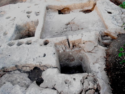
Vats.
During the third week of the field season, the Area M team moved down from the tel to Area K, located at the foot of the northern slope just south of the alluvial terrace that extends to ‘Ein Jezreel, in order to expose the remains of an agricultural installation that included a square rock-cut vat and other rock-cut depressions that we discovered during our 2012 survey and labeled 12/K/01.
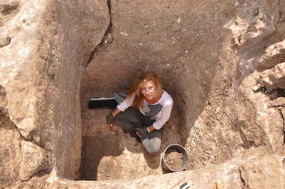
After the excavation team cleared the topsoil in an area of approximately 12 square meters, they exposed a rock-cut treading floor measuring approximately 3.20 square meters and two adjacent rock-cut vats each ca. 1.30 meters square and over one meter deep. Surrounding these features are numerous conical rock-cut mortars and a large oval rock-cut vat that is ca. 0.90 meters in diameter. According to visiting expert Dr. David Eitam, the complex appears to date to the Iron Age (possibly 10th-9th c BCE) and may be one of the largest winery installations dating to this period in Israel.
Vat.
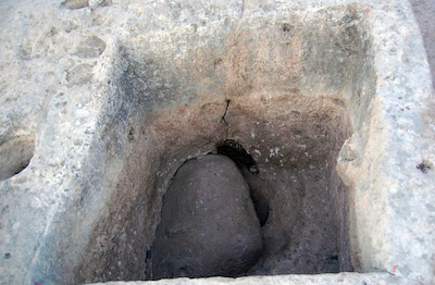
Also of interest in Area K are visible basalt ‘protrusions’ that marked the geological transition from the limestone of the natural hill of Jezreel to the basalt flow that lies under the terrace and is exposed above the spring. One of the square rock-cut vats features an example of this phenomenon. It appears that those who carved the vat out of the limestone bedrock hit a large basalt boulder and, unable to remove it, cut around it and thus incorporated it within the vat. Other attempts to cut around protruding basalt boulders were seen in other parts of the winery. Excavations will continue in this area in future seasons as we seek to expose the entire winery and some of the quarrying areas that surround it. Although the latest use of the winery cannot yet be determined, evidence of quarrying in later periods can be seen along the southern edge of the treading floor.
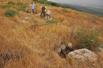
Area S
the Left.
The third area and main stratigraphic excavation was in Area S, which is located on the eastern part of the uncultivated land – masha – that is directly south of and above the spring. This area was so overgrown that it was impossible to survey on foot in 2012; however, the LiDAR aerial laser scan suggested building remains in the eastern part of this area and this led us to focus our attention on this area in our inaugural excavation season. Two teams – one led by Ms. Noga Blockman of Tel Aviv University and Dr. Julye Bidmead of Chapman University and the other by Mr. Ian Cipin of the University College London – opened a total of 10 five x five meter squares in this area and revealed architectural remains dating to several phases of the Early Bronze Age (ca. 3,600-2,000 BCE).
We were fortunate that a bonfire lit several weeks prior to the excavation season to celebrate the Lag B’Omer holiday had burned the undergrowth in this area to the ground; we were then able to clearly see the dense concentration of pottery, basalt artifacts and flints that lay across the surface of the eastern part of the masha prior to setting our squares. Just below the topsoil a substantial layer of stones composed of a mix of densely packed limestone fieldstones and several hundred broken basalt grinding stones that had been purposely laid down for an as-yet unknown purpose. This stone mantle may date to the Middle Bronze Age (ca. 2,000 BCE) or slightly earlier. Immediately below the stone cover was a series of walls and surfaces belonging to some four architectural phases. We are currently analyzing the abundant pottery sherds and flint tools, but the preliminary data suggest that we have most if not all the phases of the Early Bronze Age (3,600-2,000 BCE) represented in this area. The large number and wide variety of basalt artifacts found in this area, including hundreds of fragments of grinding slabs, handstones, mortars, pestles, bowls, pounders, shaft straighteners and more, is particularly interesting as it suggests that these broken items were purposely collected and laid down among limestone fieldstones to create the stone cover that sealed the architectural remains. Although the architecture in this area appears to date to the Early Bronze Age, some of the ceramic and lithic remains can be dated to the late Neolithic and Chalcolithic periods (6,500-3,600 BCE).
Conclusion
The Jezreel Expedition field school included an intensive lecture and field trip program, with eleven evening lectures given by archaeologists, religion scholars and historians and study tours to 16 cultural and historical sites all over the country. Participants had the opportunity to visit not only major archaeological sites like Banias, Bet Shean, Caesarea, Dan, Gezer, Hazor, Jerusalem and Megiddo, but also the Kimmel Center for Archaeological Science at the Weizmann Institute in Rehovot, the Druze village of Daliyat al-Karmel and the nearby Sachne hot springs and adjacent regional museum. All participants lodged at Kibbutz Yizre’el and we wish to thank members of the kibbutz for their generous help, hospitality and friendship.
Works Cited
Ebeling, J., N. Franklin and I. Cipin. 2012. Jezreel Revealed in Laser Scans: A Preliminary Report of the 2012 Survey Season. Near Eastern Archaeology 75/4: 232-239.
Franklin, N. 2008. Jezreel: Before and after Jezebel. Pp. 45–53 in Israel in Transition: From Late Bronze II to Iron IIA (c. 1250–850 BCE), Volume 1: The Archaeology, ed. L. L. Grabbe. New York: T&T Clark.
Moorhead, T. S. N. 1997. The Late Roman, Byzantine and Umayyad Periods at Tel Jezreel. Tel Aviv 24:129–66.
Ussishkin, D., and J. Woodhead. 1992. Excavations at Tel Jezreel 1990–1991: Preliminary Report. Tel Aviv 19:3–56.
Zori, N. 1977. The Land of Issachar: Archaeological Survey [Hebrew]. Jerusalem: Israel Exploration Society.
Comments (3)
It is sometimes difficult for a non-archaeologist to know what is the significant detail in these reports. Have any existing ideas about the very early period in Palestine been shaken by these discoveries?
#1 - Martin - 08/13/2013 - 17:08
Thank you very much for your comment. The 2013 excavation season ended only in mid-June, and we still have a lot of data to analyze in the months to come. We hope that our discoveries in Area S, near the spring, will add to our knowledge of prehistoric and Early Bronze Age settlement in the Jezreel Valley, and we believe that our excavations on Tel Jezreel will eventually resolve longstanding issues related to the dating of the site during the Iron Age. We would also like to explore the connection between Jezreel and Samaria in the Iron Age (and perhaps shed light on the biblical stories of Omri, Ahab and Jezebel) and further investigate what might be called a “royal” winery at Jezreel dating to this period. We have much more work to do and look forward to adding more pieces to the puzzle that is the history of Jezreel in the years to come.
#2 - Jennie - 08/14/2013 - 01:59
Nice and explicit report.
it misses an aerial view of the site, to make it more clearer.
#3 - Sharon - 08/14/2013 - 13:26